


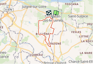
SityTrail - Buchêne

patrando49
User

Length
9.2 km

Max alt
64 m

Uphill gradient
65 m
Km-Effort
10 km

Min alt
25 m

Downhill gradient
65 m
Boucle
Yes
Creation date :
2019-03-17 13:16:10.251
Updated on :
2025-05-05 17:01:27.763
2h16
Difficulty : Medium

FREE GPS app for hiking
 SityTrail
IGN / Geographical institutes
SityTrail Plus
The world is yours!
About
Trail Walking of 9.2 km to be discovered at Pays de la Loire, Maine-et-Loire, Les Garennes-sur-Loire. This trail is proposed by patrando49.
Positioning
Country:
France
Region :
Pays de la Loire
Department/Province :
Maine-et-Loire
Municipality :
Les Garennes-sur-Loire
Location:
Saint-Jean-des-Mauvrets
Start:(Dec)
Start:(UTM)
692324 ; 5252389 (30T) N.
Comments